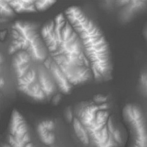
Height Field - Digital Elevation Map (DEM)
A height field or digital elevation map is a matrix of elevation values. Each matrix entry corresponds with a specific height of a surface. For that reason, it is often described as a 2.5D data structure. Analog to the term pixel (picture element), a heixel is one element of a height field.
A height field is typically represented by a greyscale image. Many regular image formats do only support 8-bit greyscale values, though. For elevation values a more precise representation is required. So a frequently used format for height fields is TIFF, because it supports 16-bit integer and 32-bit float values.

Height field of Yukon Territory, Canada.
See the corresponding imagery.
If the height field is geo-referenced, then it matches a part of the earth’s surface. A common format to encapsulate geo-referenced elevation data is the GeoTiff format as implemented by the GDAL library. GeoTIFF is an extension of the TIFF image format that can encapsulate the necessary geo-referencing information via TIFF tags.
Real-world elevation maps are created with remote sensing techniques. A satellite acquires stereo image pairs of the same spot on earth. From the stereo image pairs the parallax shift can be reconstructed, which, in turn, relates to the distance of the earth’s surface to the satellite. By knowing the satellites orbit, the elevation at the particular spot on earth is given as the difference of the orbit and the distance.
This method falls into the indirect category of remote sensing techniques, but there also exist direct elevation measurement techniques. The most well known direct method uses the Radar Doppler effect to measure the distance directly. This was also the technique being employed during the SRTM flight of the Endeavour Space Shuttle.
The Shuttle Radar Topography Mission (SRTM) obtained elevation data on a near-global scale to generate the most complete high-resolution digital topographic database of Earth. SRTM consisted of a specially modified radar system that flew onboard the Space Shuttle Endeavour during an 11-day mission in February of 2000. SRTM data is available freely at the Global Land Cover Facility.